©1999 Terry Gruber
Historical Background of the Fort Edwards Site
The bloody aftermath of the failed Braddock campaign of 1755 against the French at the Forks-of-the-Ohio provided the motivation to build protective structures on the Virginia frontier. One of those structures, called by contemporaries Edwards’s Fort, became a vital post in colonial Virginia’s plan for the defense of its frontiers. But the history of the fort does not really begin in those terrible months following the Braddock debacle. The history begins with the arrival of one of the area’s first settlers, Joseph Edwards.
It is not clear when Joseph Edwards arrived with his family and that of his brothers’ in the Cacapon River Valley. Various genealogical publications state the arrival as early as the late 1720’s to the early 1740’s. The most likely period, based on public documents and regional academic research, suggests the late 1730’s ( Gruber, 3; Mitchell, 15-58; Puglisi, 25-98). It wasn’t until 26 May 1748 that Edwards acquired official title from Lord Fairfax, based on a survey of 400 acres "lying on Great Cacapehon" by James Genn (Edwards Land Grant, digital copy). George Washington became familiar with Joseph Edwards and the Cacapon Valley since he was serving an apprenticeship to Genn on this surveying expedition.
 Very
little is known about Joseph Edwards prior to his arrival in the Cacapon River
Valley*. According to a deposition made in 1770, he was born in 1718.
His place of birth is unknown. In the deposition Edwards stated that he lived
with William Hyatt in 1736 in what was then Orange County, Virginia. He was
probably living on the Cacapon by 1744, based on a lawsuit brought by him
against a fellow frontiersman, James McCracken, who lived on Patterson Creek (Shanklin,
n.d.). By 1751, Edwards had obtained some measure of prominence when he was
appointed a Justice of the Peace for Frederick County (Frederick County Order
Book #4, 101). At the same time he served as Surveyor of the Road from Jeremiah
Smith’s, on Back Creek, to the North River. A Justice of the Peace was the
most important and powerful position in local government during the colonial
period. The position was usually held by men of social prominence and means in
the community (Katz and Murrin, 410-421). A further indicator of increasing
wealth and status is evident by his
Very
little is known about Joseph Edwards prior to his arrival in the Cacapon River
Valley*. According to a deposition made in 1770, he was born in 1718.
His place of birth is unknown. In the deposition Edwards stated that he lived
with William Hyatt in 1736 in what was then Orange County, Virginia. He was
probably living on the Cacapon by 1744, based on a lawsuit brought by him
against a fellow frontiersman, James McCracken, who lived on Patterson Creek (Shanklin,
n.d.). By 1751, Edwards had obtained some measure of prominence when he was
appointed a Justice of the Peace for Frederick County (Frederick County Order
Book #4, 101). At the same time he served as Surveyor of the Road from Jeremiah
Smith’s, on Back Creek, to the North River. A Justice of the Peace was the
most important and powerful position in local government during the colonial
period. The position was usually held by men of social prominence and means in
the community (Katz and Murrin, 410-421). A further indicator of increasing
wealth and status is evident by his
Edwards lived near Capon Bridge, beginning at the northern boundary of the town
acquisition of at least one indentured servant (Frederick County Order Book #5, 268). After Hampshire County was formed out of Frederick and Augusta Counties, Edwards does not appear to have continued as a Justice of the Peace, possibly because he was seldom present at the county court sessions while Justice for Frederick County.
Beginning in 1750, Edwards began obtaining several tracts of land in the Cacapon and North River Valleys. In addition to his original 400 acre grant, Edwards secured grants for an additional 1239 acres between 1750 and 1762. He apparently increased his yearly income during the years of the French and Indian War by fulfilling military contracts (Shanklin, n.d.). It is enigmatic that, with the apparent accumulation of wealth from the late 1740’s to the late 1760’s, Edwards died in the spring of 1781 with personal property valued only at £8:11:0, leaving the original grant and one on Dillons Run to heirs (Hampshire County Will Book #2, 72).
It is not likely, contrary to most genealogical narratives, that Edwards constructed a fort on his land when he built his house. Although there are no surviving records which can date the fort, looking at neighborhood fort construction on the frontier of Pennsylvania indicates that private forts were constructed when Indian raids were imminent, often long after initial settlement (Waddell and Bomberger, 75-84). Edwards’s Fort was probably built in the fall of 1755, when Indian raids began to occur in Hampshire County.
 Looking
at journals and diaries of contemporary travelers in the spring and fall of 1755
reveals no mention of a fort at Edwards’s within the narrative. Sir John St.
Clair, while investigating the best route for the Braddock expedition to travel
to Fort Cumberland, described Edwards’s place along the Winchester to South
Branch road simply as "a good Camp" with no mention of a fort (St.
Clair Letterbook, 69). A good camp for the British army was one that had dry
ground for tents, pasture for forage and straw making, and some defensible
qualities. A fort present at the site probably would have warranted a mention
since that would be a unique feature among camp sites for the army. Captain
Charles Lewis, while taking his newly formed company to its station at Fort
Cumberland in the early fall of 1755, commented on several notable things as he
passed through Hampshire County and by Joseph Edwards’s home. He said nothing
about Edwards’s, choosing to remark about abandoned and destroyed homes
elsewhere (Lewis Journal, 12-14).
Looking
at journals and diaries of contemporary travelers in the spring and fall of 1755
reveals no mention of a fort at Edwards’s within the narrative. Sir John St.
Clair, while investigating the best route for the Braddock expedition to travel
to Fort Cumberland, described Edwards’s place along the Winchester to South
Branch road simply as "a good Camp" with no mention of a fort (St.
Clair Letterbook, 69). A good camp for the British army was one that had dry
ground for tents, pasture for forage and straw making, and some defensible
qualities. A fort present at the site probably would have warranted a mention
since that would be a unique feature among camp sites for the army. Captain
Charles Lewis, while taking his newly formed company to its station at Fort
Cumberland in the early fall of 1755, commented on several notable things as he
passed through Hampshire County and by Joseph Edwards’s home. He said nothing
about Edwards’s, choosing to remark about abandoned and destroyed homes
elsewhere (Lewis Journal, 12-14).
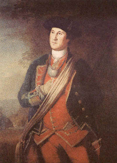
Washington, in Virginia Regiment uniform
Edwards’s home or fort began to be used for military purposes beginning in October 1755 when a militia company, patrolling west of the Cacapon River in the South Branch valley, was ordered to stop its eastward withdrawal at Edwards’s (GW Papers, 2:93). The fort began more regular use in April 1756, when a large party under the command of Captain John Fenton Mercer was briefly stationed there (GW Papers, 3:10). The fort usually had a garrison of 10-15 men under a subaltern (Ansel, 78).
The most significant event to occur at Edwards’s was the defeat of a Virginia provincial force of approximately 60 men engaged against a larger force of nearly 100 French and Indians. The 30-minute battle occurred on 18 April 1756. The Virginia Regiment company of Captain John Fenton Mercer lost 15 men in the battle, including Mercer and Ensign Thomas Carter, while inflicting losses on the opposing force of at least nine Indians. This was the largest battle which occurred in Virginia during the war. The battle had a sobering effect upon the Virginia legislature, transforming a balky House of Burgesses to a supportive body when they appropriated over £20,000 to the war effort (GW Papers, 3:17-18, 72-4, 76, 77-9; Titus, 92-4). It is worth noting that the famous Revolutionary War general, Daniel Morgan, was possibly recovering from some serious wounds received the day before while on the road between Edwards’s and Ashby’s forts.
In May of 1756, the legislature authorized the construction of a "chain of forts" to extend from the northern Potomac frontier to the southern frontier on the Mayo River. In a Council of War held on 10 July 1756 to determine which existing forts would be considered a part of the chain, Fort Edwards was included in the chain, thus assuring it a garrison of provincial troops and regular occupation as well as regular maintenance (GW Papers, 3:243-46). Edwards’s was chosen as one of the Virginia-maintained forts because of its location on the main road of communication between Colonel George Washington’s headquarters in Winchester and the forts on the South Branch of the Potomac and Fort Cumberland. Edwards’s was 25 miles from Winchester, a full day’s journey from the headquarters. The fort would serve as a way station for supply and dispatch convoys through 1758.
After the fall of Fort Duquesne in November 1758, Edwards’s Fort was probably abandoned by the Virginia Regiment. The region was stabilized after the main avenue that raiding parties took to the Virginia frontier was shut off by British occupation at the Forks-of-the-Ohio. A return of the Virginia Regiment, dated 28 May 1760, indicates the regiment was stationed at the forts in Pennsylvania and on the Augusta County frontier (Byrd Return, reel C-366). Reports of Lieutenant-Governor Francis Fauquier to the Board of Trade indicate that the colony was maintaining no forts on the Virginia frontier in 1763 and 1765 (Fauquier papers, 2:1016, 3:1318). The fort may have been used intermittently by the militia until the end of Pontiac’s rebellion in 1764, after which forts were no longer needed. During the next decade, the frontier would move westward to the Ohio River.
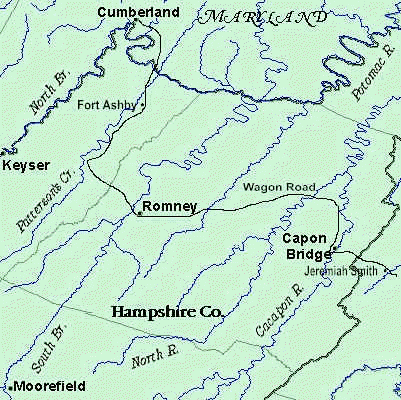
Of significance to the Fort Edwards site is the presence of the first publicly constructed and maintained road into the region west of the Shenandoah Valley. The road was constructed in several stages, the first from Winchester to James Caudy’s plantation on the Cacapon River in 1742** and the second stage in 1744 from Caudy’s to the South Branch Valley in the vicinity of present Old Fields, Hardy County. Later additions pushed the road westward from Job Pearsall’s to Patterson Creek. The road appears in the Fry and Jefferson map of 1755*** with Edwards’s clearly placed on the road after it crosses the Cacapon River to the west bank. Local tradition holds that the river crossing and road cut through Edwards’s land in a westerly course. The Fry and Jefferson map and preliminary research by the author suggests the road crossed the Cacapon on James Caudy’s land and proceeded to course northward, cutting through Edwards’s land near its western boundary. Edwards’s was recognized by both Washington and St. Clair as a good way station when traveling on the road (Gruber, 3-5; Fry and Jefferson, map). By the 1790’s, the Northwest Turnpike was constructed to the south on Caudy’s land and continued west after crossing the Cacapon, bypassing Joseph Edwards’s former home and relegating the site to obscurity.
* Confusing research is the fact that there were two, unrelated, Joseph Edwards’s living in Frederick County. The other Edwards lived on Opequon Creek.
** Caudy lived on the grant adjacent and south of Edwards’s grant.
***This map has the date of 1775 on it but is more likely 1755, since both Fry and Jefferson were deceased by 1775.
Bibliography
Abbott, W.W., ed. The Papers of George Washington: Colonial Series. Charlottesville: University Press of Virginia, 1983-95. 10 vols.
Ansel, William H., Jr. Frontier Forts Along The Potomac And Its Tributaries. Parsons, WV: McClain Publishing Co., reprint 1995.
Byrd, William, III. "A General Return of the Virginia Regiment of Foot Commanded By The Honorable William Byrd, Colonel … Fort Loudoun May 28th, 1760". National Archives of Canada: Northcliffe Collection, Series 1: Robert Monckton papers, MG 18, M, Volume 37, microfilm reel C-366.
Frederick County. Order Book #4-5. Winchester, VA: Frederick County Courthouse.
Fry, Joshua and Peter Jefferson. "A Map of the Most Inhabited Part of Virginia, Containing The Whole Province of Maryland, With Part of Pennsylvania, New Jersey, and North Carolina". Ashford, Kent: Headley Brothers, Ltd. n.d., reprint.
Gruber, Terry R. "Colonial Hampshire County Road Orders". Hardy County West Virginia Genealogical Webpage, <http://www.rootsweb.com/~wvhardy/hcnotes.htm>.
Hampshire County. Will Book #2. Romney, WV: Hampshire County Courthouse.
Katz, Stanley N. and John M. Murrin, eds. Colonial America: Essays In Politics and Social Development. New York: Alfred A. Knopf, 3rd ed., 1983.
Lewis, Charles. Journal of Captain Charles Lewis of Fredericksburg, Virginia, when in the service of the colony of Virginia in the year 1755. Richmond: Virginia Historical Society, n.d.
Library of Virginia. "Joseph Edwards Land Grant". Northern Neck Land Grants, in Digital Card Catalog, <http://198.17.62.51/cgi-bin/drawer/disk19/CC150/0593/E0059?47>
Mitchell, Robert D., ed. Commercialism and Frontier: Perspectives on the Early Shenandoah Valley. Charlottesville: University Press of Virginia, 1977.
Puglisi, Michael J., ed. Diversity and Accommodation: Essays on the Cultural Composition of the Virginia Frontier. Knoxville: The University of Tennessee Press, 1997.
Reese, George, ed. The Official Papers of Francis Fauquier, Lieutenant Governor of Virginia: 1758-1768. 3 vols. Charlottesville: The University Press of Virginia, 1983.
Shanklin, Sue Morfit. "Joseph Edwards, 1718-1782". Unpublished manuscript, 5 pages.
St. Clair, Sir John. Journal. In John Forbes Papers, 1755-1759, Accession #10034. University of Virginia Library, Charlottesville, VA.
Titus, James. The Old Dominion At War: Society, Politics, and Warfare in Late Colonial Virginia. Columbia: University of South Carolina Press, 1991.
Waddell, Louis M. and Bruce D. Bomberger. The French and Indian War In Pennsylvania, 1753-1763: Fortification and Struggle During the War for Empire. Harrisburg: The Pennsylvania Historical and Museum Commission, 1996.